Read Time 5 mins
20/12/2023
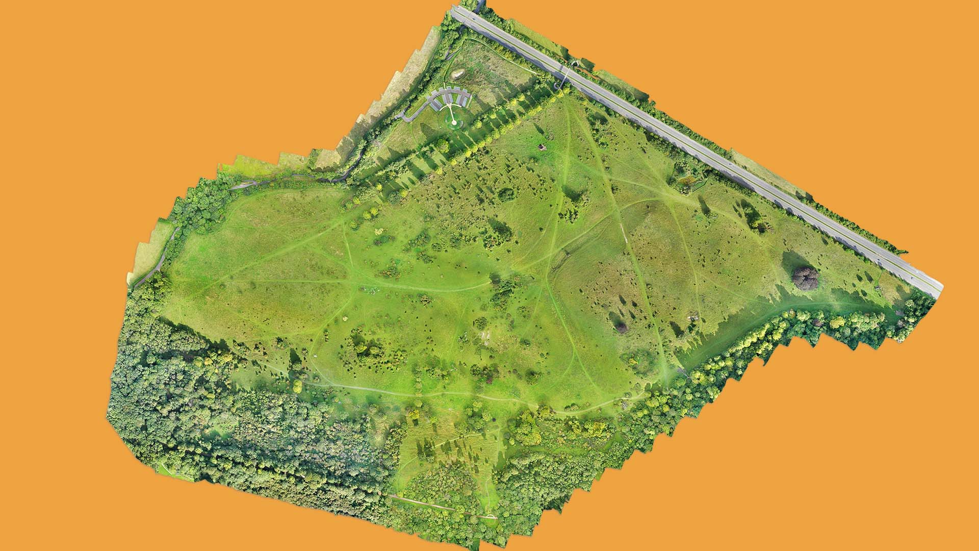
Table of Contents
Introduction to Orthomosaic MappingThe Importance of Orthomosaic Maps
How Orthomosaic Mapping is Captured by Drones
The Role of Ground Control Points in Orthomosaic Mapping
Software Applications for Orthomosaic Maps
Conclusion: The Future of Orthomosaic Mapping
Contact Carrot Drone Services
Introduction to Orthomosaic Mapping
Orthomosaic mapping, a revolutionary technology in the field of aerial surveying, is redefining how we capture and interpret geographical data. Utilising state-of-the-art drone technology, Carrot Drone Services offers unparalleled precision and detail in mapping services. This section will explore the fundamentals of Orthomosaic Mapping, delving into its methodology, significance, and the edge it provides in various applications. As an emerging tool in spatial analysis, Orthomosaic Mapping is not just about capturing images; it's about creating a comprehensive, accurate, and interactive representation of the terrain that serves a multitude of purposes across diverse industries.
The Importance of Orthomosaic Maps
Orthomosaic maps, generated by meticulously stitching together hundreds of high-resolution drone photos, serve as a critical tool in various industries. These detailed, accurate maps are not just photographs; they are rich data sources offering insights and solutions to numerous challenges. From urban planning and construction to agriculture and environmental conservation, orthomosaic maps provide a level of detail and scale accuracy that traditional methods cannot match.
In construction and urban development, these maps assist in site planning and monitoring, offering a comprehensive view that aids in efficient project management. In agriculture, they help in precision farming, enabling farmers to monitor crop health, irrigation needs, and land use more effectively. Environmentalists use these maps for ecosystem monitoring, tracking changes in natural habitats, and assessing the impact of human activities.
The pain points addressed by orthomosaic mapping are vast. It reduces the time and resources spent on ground surveys, minimises human error, and provides a level of detail that supports better decision-making. In disaster management, these maps are invaluable for assessing damage and planning effective responses. For any industry requiring detailed geographical information, orthomosaic maps are not just useful; they are indispensable.
Drone mapping can be used for:
- Documenting project progression
- Cut & Fill calculations
- Volumetric calculations
- Improving communication with all agencies involved
- Dynamic & timely decision making
- Keeping clients informed of progress
- Fast & safe site inspections
- Locating areas of workflow that can be improved & streamlined
- Observation of hinderences/stoppage
- Checking conformance to schedule
- Assessment of quality of work
- Assessment of stored supplies
- Asset monitoring
- Resolving scheduling issues with staff and supplies which may have occurred due to lack of up to date information
- Dispute resolution
- Evaluating compliance with appropriate regulations
- Topographical surveys
- Locating drainage spots
- Studying vegetation
- Studying water ways
- Optimising grading & earthwork plans
- Comparing differences from "as built" to the original plans
How Orthomosaic Mapping is Captured by Drones
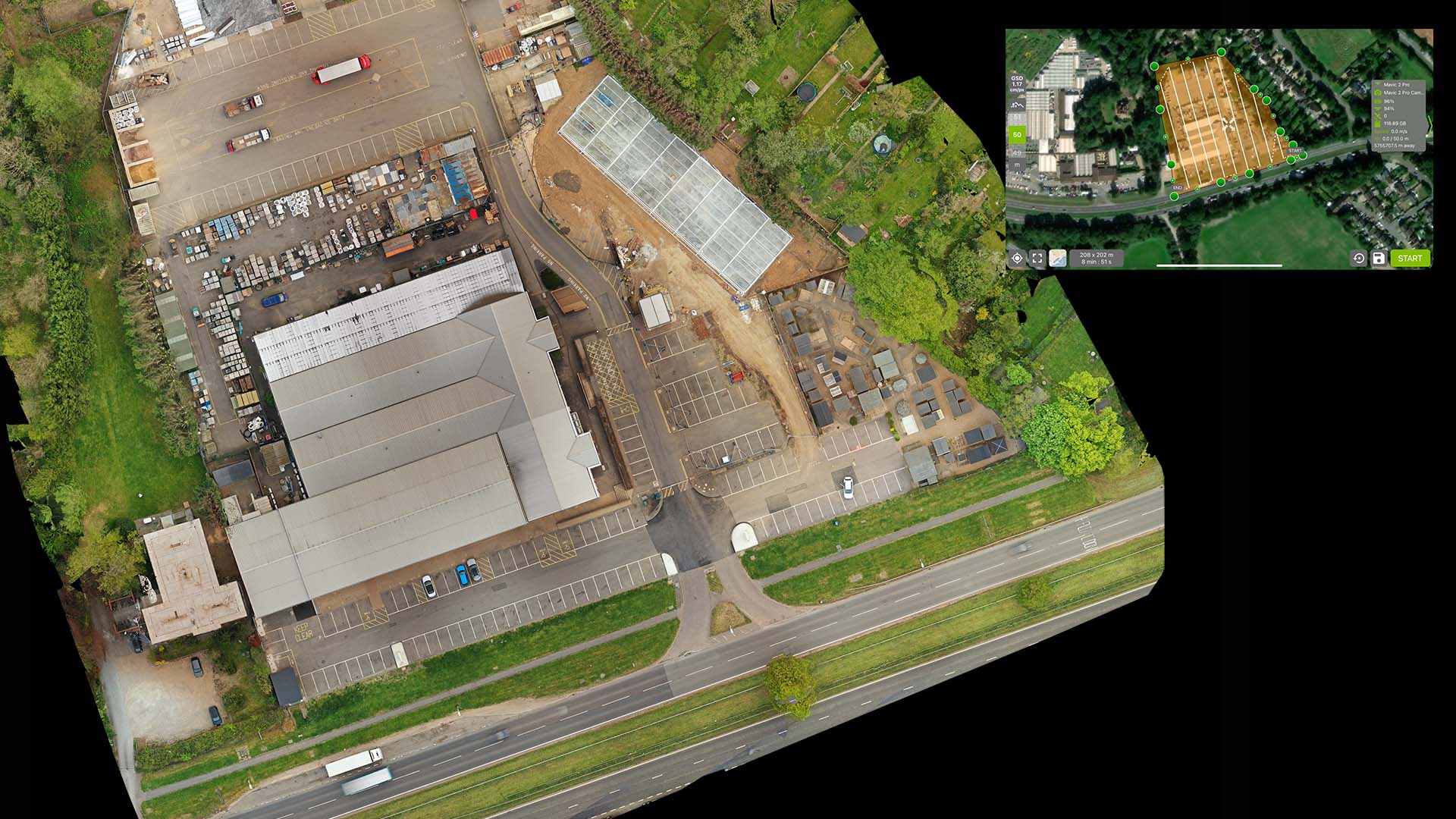
The process of capturing images for orthomosaic maps with drones is a blend of art and precision engineering. Carrot Drone Services utilises advanced drones equipped with high-resolution cameras that systematically cover the target area. These drones, flown at a consistent altitude, capture a series of overlapping images, ensuring every part of the landscape is covered from multiple angles.
One of the primary advantages of using drones for mapping is their ability to access difficult terrains and large areas quickly, providing data that would be time-consuming and costly to gather through traditional ground-based methods. Drones offer a unique perspective, capturing data from angles not possible by manned aircraft or satellite imagery. This flexibility makes drones ideal for a wide range of mapping needs, from urban planning to environmental monitoring.
The technical aspects of image capture are central to the quality of the final orthomosaic map. Carrot Drone Services ensures that each image meets stringent criteria for resolution, clarity, and overlap. The drones are equipped with GPS and gyro-stabilised gimbal systems, ensuring images are sharp and geographically accurate. This attention to detail in the image capture phase lays the foundation for creating a high-quality, highly accurate orthomosaic map that can be relied upon for critical decision-making.
The Role of Ground Control Points in Orthomosaic Mapping
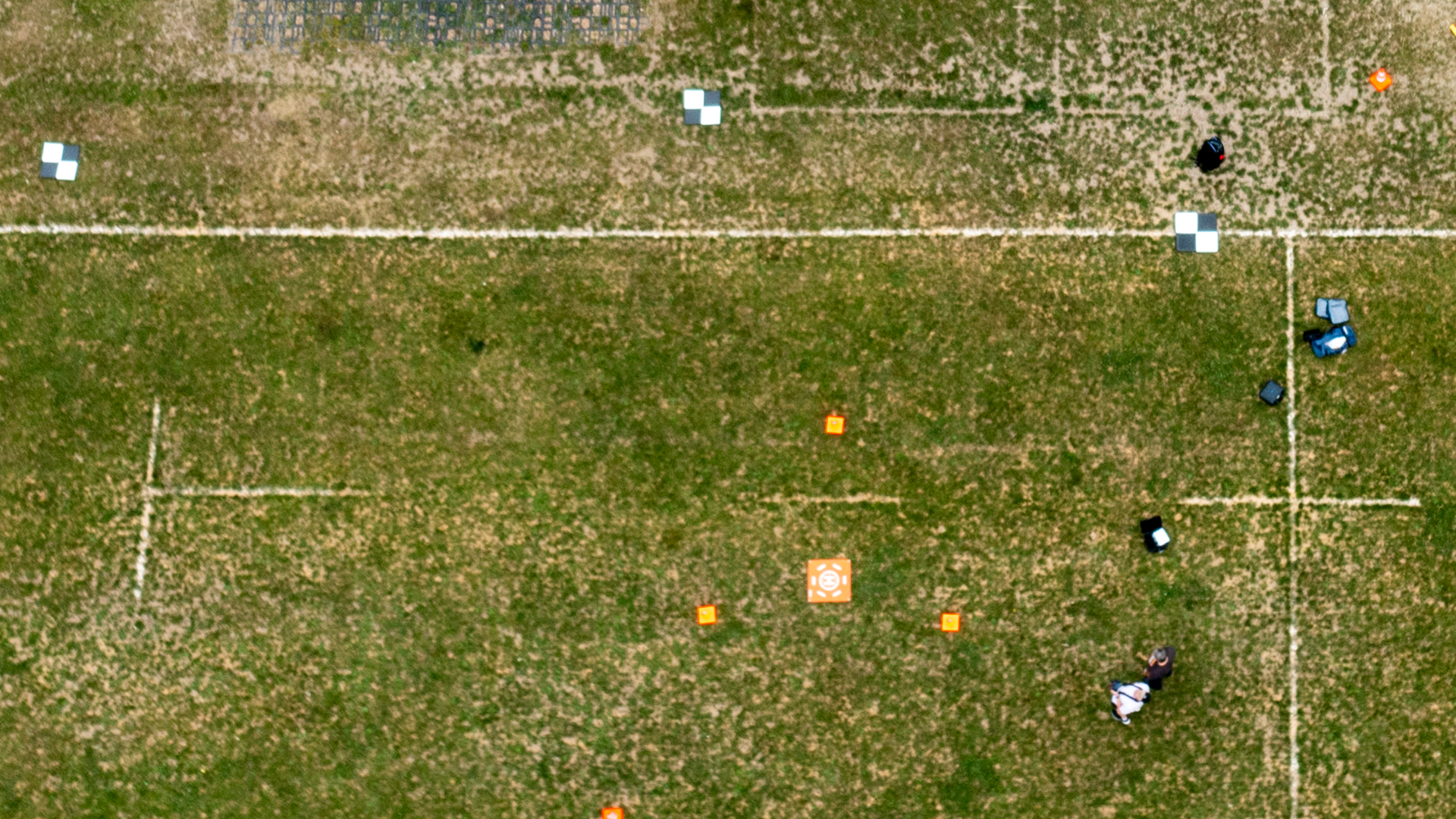
Ground Control Points (GCPs) are a crucial element in creating highly accurate orthomosaic maps. GCPs are specific points on the ground with known geographic coordinates. These points are used as references to calibrate and validate the data captured by drones, ensuring the orthomosaic maps are not only detailed but also precisely accurate in terms of real-world coordinates.
The inclusion of GCPs significantly enhances the accuracy of orthomosaic maps. While drones equipped with GPS systems provide a level of geospatial accuracy, GCPs offer an additional layer of validation. By matching the aerial data with the ground truth provided by GCPs, Carrot Drone Services ensures that the orthomosaic maps accurately represent the surveyed area, with minimal geographical distortions.
The process of integrating GCPs with drone technology involves careful planning and execution. Before drone flight, GCPs are strategically placed throughout the survey area and their exact locations are recorded using high-precision GPS equipment. During post-processing, these GCP coordinates are used to calibrate the drone imagery, aligning it accurately with real-world coordinates. This integration of GCPs with advanced drone technology is what sets professional orthomosaic mapping apart, delivering a product of exceptional accuracy and reliability.
Software Applications for Orthomosaic Maps
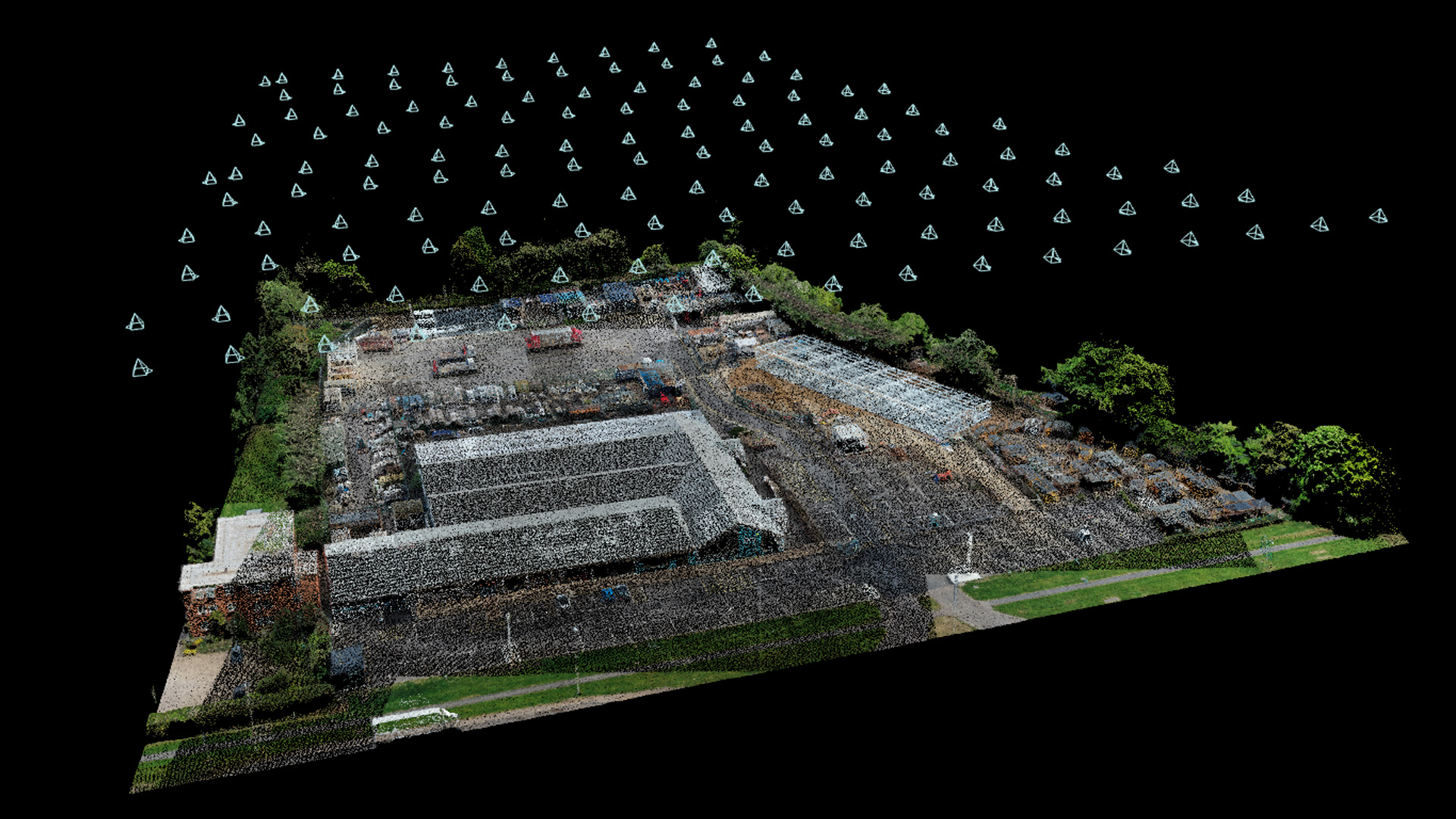
The creation of an orthomosaic map is not complete without the critical step of processing the captured images. This is where specialised software applications come into play. Carrot Drone Services employs cutting-edge software that efficiently stitches together the drone-captured images into a seamless, highly detailed orthomosaic map. These software solutions are equipped with powerful algorithms that handle vast amounts of data, ensuring accuracy and detail in the final product.
Different software solutions offer a range of features, including automated image stitching, color correction, and geometric adjustments to counteract the effects of drone movement and terrain variations. These features ensure that the final map is not only accurate but also visually coherent and useful for various applications. Advanced software also offers analytics capabilities, allowing users to extract meaningful insights from the maps, such as vegetation indices in agriculture or elevation data in construction.
A key aspect of these software solutions is their compatibility with industry-specific tools. Whether it's GIS software for urban planning, CAD tools for construction, or specialised agricultural mapping software, the orthomosaic maps created by Carrot Drone Services are designed to be easily integrated. This compatibility ensures that the maps can be immediately put to use in various workflows, making them a versatile asset across multiple sectors.
Conclusion: The Future of Orthomosaic Mapping
Orthomosaic mapping, as demonstrated by Carrot Drone Services, represents a significant leap forward in the field of aerial surveying and geographic data analysis. The benefits of this technology are evident across a wide range of applications, from urban planning and construction to agriculture and environmental conservation. The accuracy, efficiency, and detailed insights provided by orthomosaic maps make them an indispensable tool for professionals in these fields.
Looking forward, the future of drone mapping technology is poised for even greater advancements. Innovations in drone hardware, improved image processing algorithms, and integration with AI and machine learning are expected to enhance the capabilities of orthomosaic mapping further. These developments promise even more precise maps, faster processing times, and new applications in various sectors. As this technology evolves, Carrot Drone Services will continue to be at the forefront, adopting the latest advancements to provide our clients with the best possible mapping solutions.
Contact Carrot Drone Services
Ready to explore how orthomosaic mapping can benefit your project? Contact Carrot Drone Services for expert consultation and services. Our team is equipped to provide tailored solutions that meet your specific needs. Connect with us to discuss how our drone mapping technology can transform your approach to data collection and analysis.
For more information and to schedule a consultation, use the hashtag #contactcarrotphotography on social media or call us at +44 3333 034874. Discover the difference precision aerial mapping can make for your business or project.
