Read Time 5 mins
13/06/2022
Why you should hire a drone operator to map land that you are looking to purchase or sell
This article explains why Aerial Drone Mapping is fast becoming a vital tool for those looking to purchase or sell land for development and how they assist in closing deals much quicker with less areas open to dispute.
With a drone we can create orthomosaic maps quickly & cheaply with results available in just a few hours capturing enormous amounts of data. The resulting orthomosaic map provides totally up to date centimetre accurate data and can be used like other layers in a GIS.
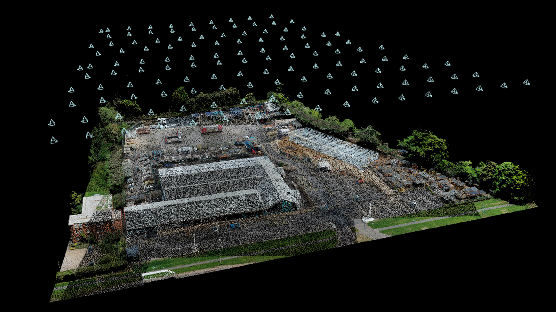
What is orthomosaic drone mapping?
Using a drone we take hundreds if not thousands of overlapping pictures of a site. Each picture is geotagged so it knows the GNSS (GPS) position of the subject matter.
We then “stitch” all the images together to create an extremely accurate high resolution geotagged image of the site. The resultant high resolution orthomosaic map offers centimetre accuracy.
From the resultant imaging we can also easily create 3D models and Point Clouds of the land.
For more information on this process please see our article here on using drone for land surveying.
The Advantages for Orthomosaic Maps for Land Sales and Purchases
The old methods of assessing the suitability of land for sale or purchase involves boots on the ground which is resource heavy, time consuming, expensive, inaccurate and, in some instances, areas remain unassessed due to lack of access.
Orthomosaic & drone mapping is used to define boundary lines and create elevation maps.
Existing utilities can be identified along with any drainage issues.
Flood Zone data can be overlayed and the foliage state assessed.
The maps, models and data can easily be shared amongst all agencies involved especially when meeting and working remotely.
All agencies will be working from the most up to date data allowing for timely and better informed decision making.
Drones are able to reach and map areas that might otherwise be inaccessible to those on the ground.
With drone mapping data being documented and stored any future disputes can be easily avoided or resolved.
Conclusion
We would thoroughly recommend that prior to putting land up for sale and inviting enquiries that you have the land mapped by drone. You will be far more likely to engage with potential purchasers and close deals more quickly.
If you are looking to purchase land then, getting the land mapped by drone, will allow you to make a far more informed decision than would otherwise be the case. Relative to the cost of a land deal the cost of drone mapping is negligible but can save you enormous amounts of money and time.
Contact us now to learn more about how we can help you with drone mapping for your land purchases and sales.